Two autumns after fire devastated grazing land in the Eden Valley regions, BIGG monitoring sites have demonstrated strong resilience of native grasses, with 90 per cent of burnt grasses having recovered.
In January 2014 the Eden Valley bushfire burnt 24,000Ha of grazing land, the vast majority comprised of native pastures. Some regions were subsequently burnt again in December 2014. From September 2014, BIGG have monitored three sites, monitoring pasture composition, dry matter, ground cover and feed quality every two months, with assistance from ecologist Nicola Barnes of Natural Resources SA Murray-Darling Basin (SAMDB). The project is funded by Natural Resources Adelaide and Mount Lofty Ranges, Natural Resources SAMDB and the Australian Government.
Twenty-four different types of plants have been identified in the monitoring paddocks, half of those native and half introduced species. The dominant native grass species across the three sites are Brushwire grass, Spear grass and Wallaby grass, and the main weeds include Geranium, Guildford Grass and Wild Oats.
The monitoring site near Moculta was selected so that burnt pasture performance could be compared side-by-side with unburnt pasture. As would be expected, dry matter (DM) per hectare has been lower in the burnt pastures. This site had been heavily grazed due to the poor spring and over the 2014/15 summer the unburnt sites had 400-500kg DM/ha compared to 1200-1400kg DM/ha in the unburnt.
In native grass pastures, groundcover is critical to capture rain and protect the surface from wind and water erosion, especially on steep country. At the Moculta site burnt pastures performed poorly in terms of groundcover, with the burned area at 77 per cent in March 2015, compared to 85 per cent in the un-burnt area. A groundcover level of at least 70 per cent is generally considered acceptable, however 90 per cent is preferred.
However native grass cover had nearly recovered at the burnt site, at 27 per cent composition (compared to 32 per cent unburnt). In addition, litter cover was the same and the cover of broad leaf weeds was lower.
A different monitoring site, which had been burnt twice, in January and again in December 2014, was monitored in March 2015, much sooner after it was burnt. On this site the native grasses had survived and were re-growing but by June 2015 the burnt area only had 50 percent groundcover and 60kg DM/ha, compared to the area that had been burnt only once which had 83 percent groundcover and 1100kg of dry matter per hectare.
The feed quality of the burned native grass is now much higher than the unburnt, due to fresh growth compared to the old unburnt plants that have a mix of dead leaf and fresh leaf. When the monitoring sites were grazed, the livestock selectively grazed on the higher quality feed of native grass regrowth compared to unburnt native grass.
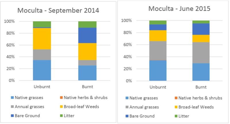
Figure 1 shows the composition of the Moculta burnt and unburnt pastures at the first monitoring in September 2014 and again at the end of May 2015. The Moculta site was burnt in the first fires, in January 2014.
In the first monitoring period, the burnt pastures had significantly higher bare ground compared to the unburnt (dark blue bar, 25 per cent compared to 1 per cent), with 26 per cent fewer native grasses (grey bar). By June 2015, the composition is now closer to the un-burnt pasture, with only 15 per cent fewer native grasses.
The results so far show that native grass cover is reduced in the short-term following fire and there is a lot more bare ground. However in the longer term, the native grasses recover and leaf litter returns, while the broad-leaf weeds are at least temporarily supressed. Fire rejuvenates native grasslands and there is a window of opportunity for land managers following a fire where careful grazing can be used to maximise grass recovery, protect soil and supress broad-leaf weeds. Over-grazing will reduce the plant density and expose the soil surface, which will then reduce future pasture production and promote broad-leaf weeds.
For more information on managing native grasses a workshop and paddock visit will be held on August 12 to discuss results from a soil survey in the grasslands area.

Figure 1: Moculta site, pasture composition in September 2014, compared with June 2015. Ground cover data collected by Nicola Barnes, Natural Resources SAMDB.
